In the previous issues, I explained the situation of supermassive Typhoon No. 6, which engulfed the 700 km long EM Graviton Barrier in the Ryukyu Islands. Conventional wisdom would dictate that it would take several years or more to recover from the damage, but as I noted at the end of the previous issue, the effects of the EM Graviton Barrier are clearly evident. Figure 1 below shows the status of shipments of “the earliest green-cut Unshu mandarin oranges in Japan,” which began under my supervision. I am quite relieved to see that all, impossible in my previous experience, would be a reality. Now, more than thirty days after the typhoon passed, nature has recovered so fully that it makes us wonder if the typhoon was merely a dream. In the past, all of this would have been unimaginable.
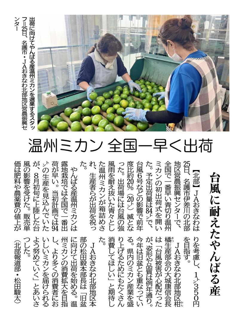
Staff members sorting Yanbaru-grown Unshu mandarin oranges for shipment at the JA Okinawa Northern Region Agricultural Promotion Center in Nago City on August 25th.
On August 25th, JA Okinawa held a ceremony marking the first shipment of green-cut Unshu mandarin oranges, the earliest in Japan, at the Northern Region Agricultural Promotion Center in Isagawa, Nago City, Okinawa Prefecture. The amount planned to be shipped came to 84 tons, a decrease of about 20% (20 tons) from the previous year due to the effects of Typhoon No. 6 and other factors. At the shipping site, boxes of lush green Unshu mandarin oranges that had survived the typhoon’s strong winds and rain were packed, and the growers celebrated the shipment.
Yanbaru-grown Unshu mandarine oranges are the earliest open-air cultivated ones to be shipped in Japan. The original production plan was for 94 tons, but the crop was negatively impacted by the typhoon that made landfall in early August. The unit sales price is targeted at 350 yen per kilogram, taking into account the increased cost of fertilizers and pesticides.
Yasunobu Oshiro, chairman of the JA Okinawa Northern District Citrus Production Committee, said, “We were worried about typhoon damage, but the shape and quality are the same as usual. This year’s harvest also coincides with the lunar calendar-based Obon festival. I hope that people will consume a lot of them to boost the prefecture’s Unshu mandarin orange industry.”
Tsuyoshi Matsuda, general manager of the JA Okinawa Northern Regional Headquarters, said, “We will start shipping for the Obon festival holiday. We will do our best to expand the consumption of Unshu mandarin oranges and deliver delicious mandarins to as many consumers as possible.”
(Shunta Matsuda, Northern News Department)
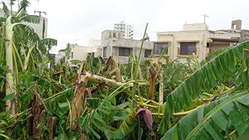
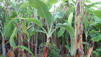
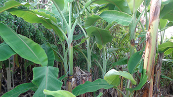
Immediately after the typhoon
7 days after the typhoon
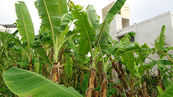
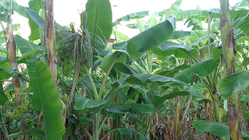
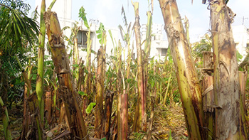
30 days after the typhoon
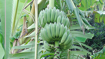
The key to recovery was the application of 50 kg of salt and 200 liters of activated EM per 10 acres immediately after the typhoon while the soil was sufficiently moist, and spraying EM・X GOLD daily in one spot to strengthen the EM graviton barrier and the Hado waves of the drip. Two weeks later, I applied a mixture of half EM Gravitron charcoal and half salt, using 15 kg per 10 acres. Fertilizing in this way produced remarkable effects, and the new leaves that have regenerated from the broken trunks have been thick and dwarfed. This result may lead to banana dwarfism (plants becoming shorter and smaller in size), which was previously thought to be impossible.
Expectation of dwarfing
Expectation of dwarf growth
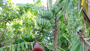
The banana plants in the less damaged areas showed unexpected growth and yielded some of the most magnificent fruits I have ever seen. The remaining fruits and flowers mentioned in the previous issue are steadily growing and will soon yield a good harvest.
30 days after the typhoon
30 days after the typhoon

Bananas harvested after the typhoon
Typhoon No. 11 hit Taiwan on September 3rd, and then reached mainland China, causing various damage. According to the forecast before August 30th, it would hit the main island of Okinawa directly, but as with previous typhoons, it began to shift significantly to the south and was pushed south of Ishigaki Island, that is, outside the EM Graviton barrier, on August 1st. (See the weather maps in Figures 2 and 3.) My hope is that we will continue to verify the data and utilize it in our efforts to counteract climate change.
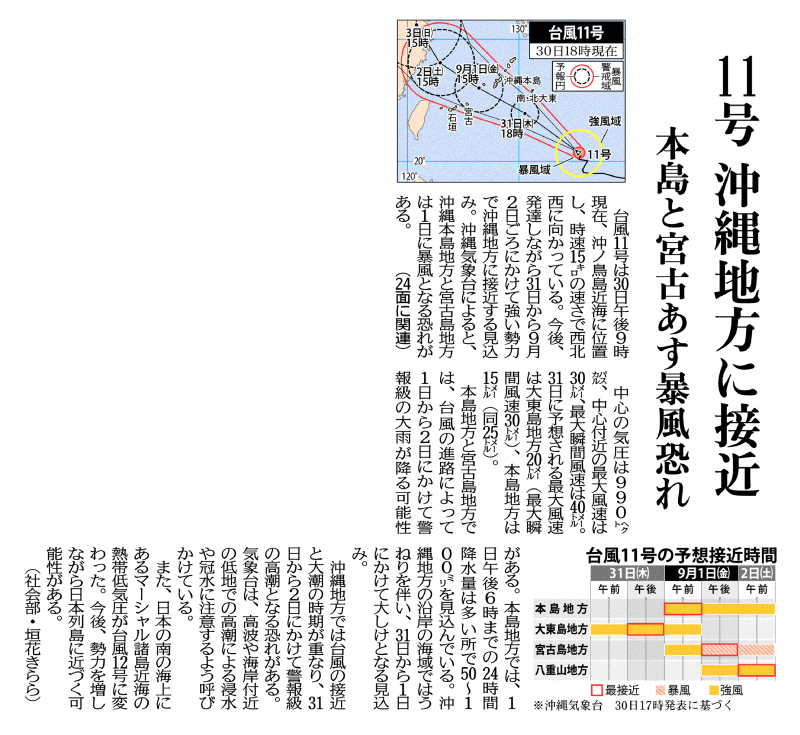
Threat of stormy winds on the main island and Miyako tomorrow
As of 9 p.m. on September 30th Typhoon No. 11 is located near Okinotori Island, heading west-northwest at a speed of 15 km/h. It is expected to continue to develop and approach the Okinawa region with strong force from the 31st to around September 2nd. According to the Okinawa Meteorological Observatory, the Okinawa main island and Miyako Island area are at risk of becoming stormy on the 1st.
The central pressure of the typhoon is 990 hectopascals, the maximum wind speed near the center is 30 meters, and the maximum instantaneous wind speed is 40 meters. The predicted maximum instantaneous wind speed on the 31st is 20 meters (with a maximum instantaneous wind speed of 30 meters) in the Daito Islands area, 15 meters in the Okinawa Main Island (with a maximum instantaneous wind speed of 25 meters).
Depending on the path the typhoon follows, warning-level heavy rainfall is possible in the main island and the Miyako Island region. In the main island region, 24-hour precipitation amounts of 50 to 100 millimeters are expected by 6 p.m. on September 1st. It is expected to cause heavy swells in the coastal waters of the Okinawa region and heavy seas are expected from the 31st to September 1st.
In the Okinawa region, the approach of a typhoon coincides with the period of high tides, and there is a risk of warning-level storm surges from the 31st to September 2nd. The meteorological observatory is advising people to be careful of flooding caused by high waves and high tides in low-lying areas near the coast. In addition, a tropical cyclone near the Marshall Islands, located off the southern coast of Japan, has turned into Typhoon No. 12. There is a possibility that it will approach the Japanese archipelago as it gains strength.
(Kirara Kakihana, Social Affairs Department)
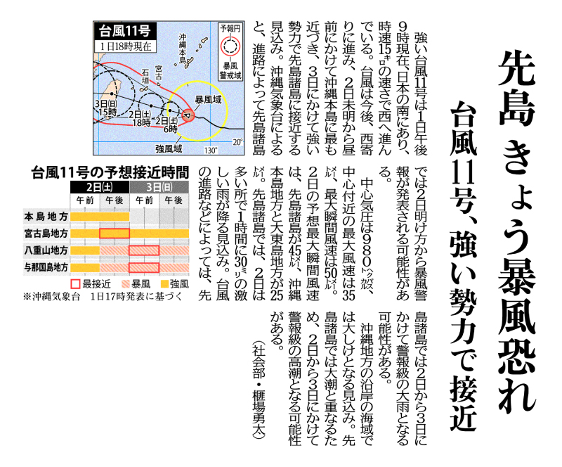
Typhoon No. 11, Approaching Japan with Strong Force
Strong typhoon No. 11, south of Japan as of 9 p.m. on September 1st, is moving westward at a speed of 15 km/h. The typhoon is expected to continue moving westward, coming closest to the main island of Okinawa from early morning to noon on the 2nd, and approaching the Sakishima Islands with strong force by the 3rd. The Okinawa Meteorological Observatory reports that a storm warning may be issued for the Sakishima Islands from dawn on the 2nd, depending on the path the storm takes.
The central pressure of the typhoon is 980 hectopascals, the maximum wind speed near the center is 35 meters, and the maximum instantaneous wind speed is 50 meters. The predicted maximum instantaneous wind speed on the 2nd is 45 meters in the Sakishima Islands and 25 meters in the Okinawa main island and the Daito Island regions.
In the Sakishima Islands, heavy rainfall of up to 30 millimeters per hour is expected on the 2nd. Depending on the typhoon’s path, there is possibility of such heavy rain in the Sakishima Islands from the 2nd and the 3rd that a warning may be issued. Heavy seas are expected off the Okinawan coast. The Sakishima Islands may experience a warning-level storm surge on the 2nd and 3rd to coinciding with high tides.
(Yuta Hiba, Social Affairs Department)
Read the original Japanese message at the link below.
2023.11.1 Updated.

EM Research Organization, Inc.|
All Rights Reserved. 2025 © EM Research Organization

